Transport & Environment
Access and Travel
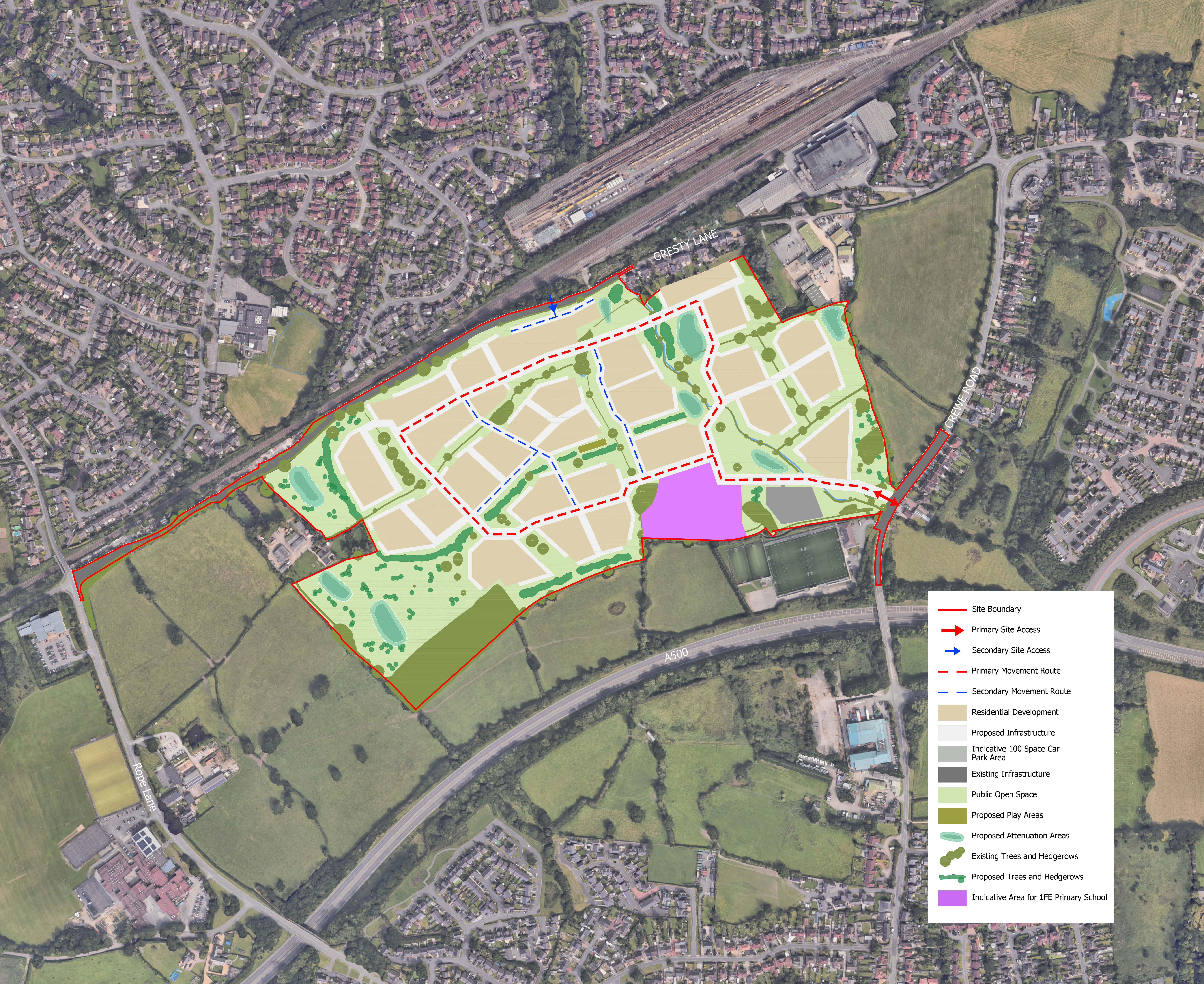
The principal vehicular access into the site will be from Crewe Road, this is proposed to be formed of a new priority junction and supplemented by a range of active travel measures. As well as providing access to the new homes, the Gresty Lane entrance will also serve the new car park at Crewe Alexandra in the Community.
A secondary access is also proposed from Gresty Lane to the north, to serve a smaller number of homes to the north as well as providing additional emergency vehicle access to the north.
An extensive network of new pedestrian and cycle routes are also proposed within the site enhancing local connectivity and access to the green and open spaces within the site. This network includes the provision of a dedicated off-highway pedestrian and cycle route along the northern boundary of the site.
As part of the planning application, we will submit a Transport Assessment which will consider and address the impact of the development on the local highway network. This exercise will use the nationally recognised TRICS database and Census data to accurately forecast and distribute traffic on key local routes.
As part of the planning determination process, we will have discussions with officers at Cheshire East Council about any potential mitigation required in the local area and ways of encouraging the use of public transport and active travel to meet daily needs.
Drainage
In accordance with the Environmental Agency’s flood risk mapping, the majority of the site is considered low risk for flooding (Flood Zone 1) with small areas in higher risk (Flood Zones 2 and 3) located along a river at the western edge of the site associated with the Swill Brook. The emerging masterplan does not propose to build any homes or vulnerable land uses within these higher-risk zones and the western boundary of the site forms part of the expansive open space network.
As part of the planning application we will submit a Flood Risk Assessment and Drainage Strategy which will be prepared in accordance with and follow national and local guidelines for sustainable drainage. This in part will detail how the masterplan responds to areas of flood risk, existing surface water flows across the site and identify how the new development would manage surface water post development. It is likely that the outline drainage strategy will utilise a mix of new attenuation basins, permeable paving, swales, and rain gardens to manage and treat rainwater before it leaves the site.
Existing ponds will be retained and where suitable, incorporated into the drainage strategy.
Environment and Sustainability
We have undertaken a wide range of surveys and assessments of the existing site and the planning application will be supported by a full ecological assessment and arboriculture (trees) assessment. These reports will detail how the proposals will achieve a minimum 10% net gain in biodiversity across the site.
The masterplan has been directly informed by the existing ecological and environmental baseline, with existing trees and hedgerows being prioritised for retention and mitigation provided wherever it is not possible to do so, such as around the new accesses into the site.
These measures will be supplemented by new tree, grassland and wildflower planting along the site boundaries and in the open spaces, supporting new and existing wildlife and habitats in the area as part of the extensive areas of publicly accessible open space throughout the site.
All homes on the site will be designed and built to meet regulations, such as the Future Homes Standard 2025, ensuring they are future-proofed for the low-carbon transition. They will feature high-performance insulation to minimise heat loss and maximise comfort, and heating and hot water will be provided by efficient low-carbon systems. Together, these measures will significantly reduce household energy use, cut carbon emissions and lower energy bills for residents.